

Parangtritis is a tourist place of the Indian Ocean coastal beaches are located approximately 25 kilometers south of Yogyakarta city. Parangtritis an object to a well-known tourism in Yogyakarta in addition to other objects such as Samas beach, Baron, Kukup Krakal and Glagah Beach. Parangtritis has unique scenery that is not in the other tourist attractions besides the big waves are also the mountain - the frequency dunes around the coast, these dunes called Gumuk.
This tourism object is managed by the local government of Bantul pretty well, ranging from lodging facilities as well as souvenir markets offering typical South '. In addition there is bathhouse called wedang machete in the bath water is said to cure various diseases including skin diseases, water from the bath containing sulfur from the mountian at these locations.Another location is the beach kusumo machetes on the beach where there is supposedly for a meeting place between the king with a queen jogjakarta southern ocean.
On certain days (usually months suro) here is offering offerings (Labuhan) for the Queen of the South Sea or in the Java language called Nyai Rara Kidul. Locals believe that a person is forbidden to use green colored clothes when they're on this coast. Parangtritis beach into a major tourist visits, especially in the Javanese New Year's Eve (1 sacred / Suro). In Parangtritis there is also horse-drawn carriage or a horse that can be rented for up the coast from east to west.

Yogyakarta city is a major city in Indonesia and is one of the Indonesian tourist attraction. The city was once the capital of Indonesia during the revolution, and now historical relics as you can enjoy one of the Indonesian tourism. Yogyakarta is the capital of Yogyakarta Special Region, led by the Sultan and Prince Pakualam Hamengkubuwono.
The food is typical of this city gudeg.
Yogyakarta is known as student city because almost 20% of the population is productive there are 137 students and universities. Yogyakarta city is a city that characterized the dynamics of school and university students from various regions in Indonesia. College owned by the government is the State University of Yogyakarta, Indonesia Institute of the Arts and the State Islamic University Sunan Kalijaga.
City Map of Yogyakarta had become the center of the Mataram kingdom between 1575-1640.Until now the Palace (Palace) was still functioning in the real sense and become an attractive tourist attraction.
In addition to the cultural heritage, tourism Yogyakarta,Indonesia has beautiful natural panorama. Green rice field surrounding countryside with Mount Merapi appeared as a backdrop. Beaches unspoiled easily found in the area south of Yogyakarta city. The people here live in peace and have a unique hospitality. Atmosphere of tourism and the arts that was in Yogyakarta.Malioboro, which is the artery of Yogyakarta, inundated with crafts from all over. Street musicians were always prepared to entertain visitors lesehan stalls.
Transportation to Yogyakarta can use the train from Jakarta, Bandung or Surabaya. There is also a fast commuter train in Surakarta named Pramex. In addition can also use the bus almost available from all cities in Java and by plane to take you to the Indonesian resort this one.

Tanah Lot tourism(bali) object is located in the Village Beraban Kediri Tabanan ,Bali district, about 13 km west of Tabanan. North Pura Tanah Lot is a temple located on the cliff that jutted into the sea.This cliff temple connect with the land and shaped like a bridge (arch). Tanah Lot, famous as a beautiful place in bali to watch the sunset (sunset), the tourists in bali are usually crowded in the afternoon to see the beauty of the sunset here not only Tanah Lot .
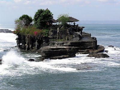
Luhur Pura Tanah Lot is built around a century by Dang Hyang VXI Nirartha, a Hindu priest Siva from the land of Java. Supernal temple on a rock cliff ocean ditengah2 Indonesia is satu2nya these attractions in Bali.
Around the temple, there is a cave wrote a breeding place sea snakes go by a sacred snake.Sacred because people say about believing that this snake is the guardian of the temple Tanah Lot.

According to legend, this temple was built by a Brahmin who wandered from Java. He is a successful Nirartha Danghyang strengthen the belief of the Balinese Hindus will be teaching and developing the heaven Sad in the 16th century. At that time the ruler Tanah Lot, Bendesa Beraben, jealous of him because his followers began to leave and follow Nirartha Danghyang.Beraben Bendesa Nirartha Danghyang told to leave the Tanah Lot. He agreed, and before he left the Tanah Lot with its power to move the boulder into the middle of the beach (not into the sea) and built temples there. He also changed into a snake scarf temple guards. This snake was still there until now and is scientifically snakes including sea snakes that have the characteristics of a flat tail like a fish, striped black and yellow and has a poison 3 times stronger than cobra snake. End of the legend has it that Bendesa Beraben 'finally' be a follower Danghyang Nirartha.
Balieo


Bratan Lake is a lake located in Bedugul area, Village Candikuning, Baturiti District, Tabanan, Bali. The lake is situated at the eastern of the two other lakes of Lake Buyan Tamblingan and lakes, which are the twin lakes cluster in a large caldera, Beratan Lake is quite special in Bali.
Being in the provincial road that connects Denpasar - Singaraja and situated close to the Eka Karya Botanical Garden makes this place became one mainstay tourist island of Bali. Besides easy reach of Lake Bratan also provides a variety of charm and adequate accommodation.
In the middle of Lake Bratan ie there is a Pura Ulun Danu who is the worship of the goddess Danu Sang Hyang as the giver of fertility.
Simple


Mount Agung is the highest mountain on the island of Bali with a height mdpl 3142. This mountain is located in the district Rendang, Karangasem - Bali.
Gunung Agung is a volcano Stratovolcano type, this mountain has a very large crater is very deep and sometimes smoke and water vapor. From this mountain Besakih seems perfectly with a pointed cone, but this mountain is elongated and ends in a circular craters and wide.
From the top of Mount Agung we can see the peak of Mount Rinjani in Lombok island, although both mountains covered with clouds as the two mountain peaks above the clouds.
Balinese Hindu community believe that Mount Agung is the place bersemayamnya gods, and also society believe that these mountains are the palace deity. Therefore, the bali make this place as a place Kramat purified.
Climbing to the top of this mountain can be started from the third route, namely:
- * From the south is of the strait through Sangkan power.
- * From the east is from Budakeling by jackfruit
- * From the south-west which is a common route used by the climbers of the Pura Besakih.
- * It is recommended for hikers to not bring food made from beef, because the area is very sacred mountain.
Bali which is one is an island in Indonesia, but it's also one of the provinces in Indonesia are much favored by many tourists. Bali lies between Java and Lombok Island. Provincial capital of Bali is Denpasar, located in the south of the island. The majority of Balinese are Hindu. In the world famous Bali as a tourist destination of Indonesia with a unique art-culture results, especially for the Japanese and Australian tourists. Bali is also known as Island of the Gods.
Island of Bali is part of the Lesser Sunda Islands along the width of 153 km and 112 km approximately 3.2 km from the island of Java. Astronomically, Bali is located at 8 ° 25? 23?South latitude and 115 ° 14? 55? East latitude tropical mebuatnya like other parts of Indonesia.
Gunung Agung is the highest point in Bali as high as 3148 m. This volcano last erupted in March 1963. Mount Batur is one of the mountain tourist island of Bali there. About 30,000 years ago, Mount Batur erupted and produced a terrible disaster on earth. Unlike in the northern, southern island of Bali is a map of lowland rivers flowed.
Based on the relief and topography, in the midst of the mountains lies the island of Bali which extends from west to east which is the object of interesting attractions and Indonesia among the mountains there are natural tourist cluster of volcanic Mount Batur and Mount Agung and the mountains are not volcanic Mount Zebra Dove, Gunung Patas, and Mount Seraya. The existence of these mountains cause the Bali tourist area geographically divided into 2 (two) are not the same part of North Bali with a narrow lowland and less sloping, and South Bali with a broad lowland and sloping. The slope of the land consists of the island of Bali flat land (0-2%) covering 122,652 ha, the land undulating (2-15%) covering 118,339 ha, steep land (15-40%) covering 190,486 ha, and land is very steep (> 40% ) covering 132,189 ha. Province of Bali has 4 (four) pieces of the lake which is located in mountainous areas are: Lake Beratan, Buyan, Tamblingan and Lake Batur.
Important places other become a mainstay of tourism in Bali, Indonesia is the art center of Ubud in Gianyar Regency is located in, while Kuta, Sanur, Seminyak, Jimbaran and Nusa Dua resort is a place that became a tourist destination, both tourism and beach resorts .
Wikipedia

National Monument or Monas is popularly called the icon City Jakarta. Feels incomplete when visiting Jakarta, but not visited monument was as high as 115 meters. However, not all parts of the Monas interest. Only certain parts of the center of the visit.
"The height of the peak is still the object Monument visitors most interested in objects than others," said manager Monas monument, Ageng Darminto, in Jakarta, this weekend.
Ageng who served as Head of Technical Implementation Unit Monas said, when the monument still has a place or other attractions worth a visit by the community.
As the museum which tells the history of Indonesia Historian, and the freedom that is where the proclamation echoed by President Sukarno and the court of the cup or the space that has meaning and symbol of the proclamation.
"Actually, Monas monument peak is not the main object, as the purpose of this monument built by the government in 1961. The main object of this monument was built to interpret the symbols of this nation through the third place, "he explained.
Today Monas monument has a total height of about 130 meters and 14 meters of them gold-plated bronze monument remains one interesting attractions for foreign tourists and domestic.
On weekends or holidays religious holidays at least an average of about 6,000 people visit the monument and most were willing to queue to climb the top of the monument using the lift provided.

Sukriadi, (28) citizens Bekasi, West Java, admitted intentionally spend time with family vacation just to see the city of Jakarta from a height of Monas monument owned.
"At the top we could observe the city of Jakarta with the breeze and her picture taken with the camera we had brought," he said.
Monas area has a total area of 80 hectares and 12 hectares of which occupied the Gambir Railway Station. On each side edge of the monument was planted with shade trees and some areas to be a place for sports for the citizens.

Mount Bromo is one of the five mountains there are mountains in complex Tengger Mountains in the ocean sand. The appeal of this mountain is a mountain that is still active. Sightseeing is Mount Bromo is a natural phenomenon with a specificity of natural phenomena that are not
found in other places is a crater in the middle of the crater (creater in the creater) with a stretch of sand surrounding sea.
found in other places is a crater in the middle of the crater (creater in the creater) with a stretch of sand surrounding sea.

Peak which is also listed as one of the top seven continents (Seven Summit) which is phenomenal and the coveted mountain climbers in various parts of the world. Mining Peak National Park is located at Laurentz, Papua. This summit covered with perpetual snow. Eternal snow Peak Mining is one of the three fields of snow in the area contained in the tropical world.
In our country through this equator, witnessed the snow in Indonesia certainly something that is impossible to beunderstood. Carstenz Pyramid (4884 mdpl) is one of the top of thethe snow. The highest peak in Southeast Asia and the Pacific located in the Sudirman Mountains series. This peak is not known only because of the high, but also because there is a layer of snow on
peak.
